It turns out it's extra dark and extra cold at 3:45am. Usually when I get up at that time I stagger down the stairs, Tokul goes out, Tokul goes into the garage, and I go back to sleep. This time I quickly got into my gear while Tokul bounced around thinking she was going to get to go along.
Unfortunately, Tokul was not going for a walk. Vesper Peak, off the Mountain Loop Highway, has talus and smooth granite slabs. Tokul has issues on hardwood floors. She'd be a disaster if they were at a 45 degree angle.
After making coffee (mmm... four shots of goodness) and a bagel I was out the door exactly at 4:30am. Right on time. Shocking. Half an hour later I pulled up in Daryl's driveway. When Daryl saw the distinct lack of Tokul in the back of the car he insisted he drive. His car has heated seats. Sweet.
It was far too early to stop at Starbucks. Not because it was too early for coffee, but because Starbucks wasn't open yet. (Come on! It's never too early for coffee.)
Another revelation was that there's no traffic at 5:30am on a Saturday. We made excellent time heading north and found ourselves in Lake Stevens just past the opening of the Starbucks there. I added a few more shots of goodness to my insides and we were back on the road.
We buzzed past a variety of small towns, which got smaller and smaller as we headed east. It was still dark and I began worrying we were going to have to either sit at the trailhead until it was light or we'd be hiking by the light of headlamps. Luckily, that last few miles took a while longer than expected and by 7:15 it was light enough to get ready. One other car shared the trailhead with us.
The trail enters into the darkness of the thick forest and heads down to a creek crossing. A few more ups and downs and we crossed the South Fork of the Stillagwamish. There's a log and a rope, but neither were necessary since the river was barely a trickle.
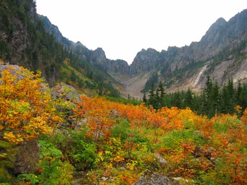
The trail leaves the woods and begins long lazy switchbacks up a slope covered with red and orange foliage. Down low the ferns and blueberries were spent, but as we climbed higher Autumn receded. At least it became more early fall and less late fall. We even found a few blueberries that were edible, if not quite delicious.
The basin opened up and the trail grew steeper. Looking back down the valley we could see clouds had rolled in and were slowly filling the basin. The way we had come was completely socked in and it continued up. We entered into a race to the pass to ensure we had some views when we got there.
At the head of the valley the trail turns to the west and became almost like a ladder. The switchbacks made it tolerable, but the final climb to Headlee Pass was brutal. We had beaten the clouds chasing us from the north, but they had also filled the valley on the other side of the pass from the south. Bugger.
Still, we were above the clouds and they made for some interesting vistas. The route dropped a bit before traversing a talus field and climbing into the the basin of Vesper Lake. The beginning of Vesper Creek spilled over the edge before disappearing from sight. Upstream the water hardly moved in the quiet of the morning. Climbing over a 20 foot pile of rocks exposed Vesper Lake itself. A few patches of snow still clung to the shore and a smooth rock island stuck out of the blue green water.
Looking around it wasn't at all clear where we needed to go other than up. I had heard that the best route was a loose gully east of the lake, but that looked nasty. Brown Beckey (a well-respected alpine guide) indicated we needed to be on a wooded ridge about 50 feet above the lake and we could see a cairn silhouetted against the sky. Of course, to get on that ridge we would need to go back to the outlet or climb straight up. Being lazy, we went up. (It wasn't really that bad. We just had to coordinate a bit to ensure I wasn't kicking rocks down on Daryl.)
Atop the ridge we found a well-defined trail that Beckey said would disappear into the trees. In reality it didn't really disappear until we left the trees and stepped onto the granite slabs that would dominate for the rest of the ascent.
In all my hiking before this summer I had only been in a slabby place once. The Chain Lakes, way up the Middle Fork of the Snoqualmie, were set in a granite basin. I'd been there in the summer of 2004. However, on Big Snow Mountain there's a bunch of slab travel and I've fallen in love with it.
Since we were on rock now there was no trail to follow. Instead, we were proceeding from cairn to cairn. (Confused? A cairn is a stack of rocks used to mark a route.) I estimated we had about an hour and another 800 feet of gain. Daryl declared he was good for about another half an hour and lay down. I revised my estimate and coincidentally it matched the amount of energy Daryl had left. How's that for convenient?
Up above I caught glimpses of a hiker heading down. He was hooded against the wind, but stopped to talk with us. I mentioned we had another 500 feet of gain to go and he said it wasn't nearly that far. Really? Good. Because Daryl was watching his watch and we had only three minutes left. Hmph.
It turns out we were only a 100 feet or so from the summit and it was an easy scramble to get there. On the summit the wind was blowing the clouds around like mad. We climbed on the rocks that marked the actual summit and looked over the edge of the north face of the mountain as it dropped away. Daryl leaned way over and that freaked me out. I can't deal with the lack of control when someone else is near a fall. Tokul seems to take a great deal of pleasure in walking right to the edge and then looking back at me. Daryl was the same way. Bum.
The views that I had promised to Daryl were non-existent. I heard from someone who was up on the summit a few hours later and it was above the clouds with spectacular views all around. To make matters worse, my tripod broke as I was trying to set up a shot. (Joby, the manufacturer, has apologized profusely and promise they're sending a new one ASAP.)
As we cooled down from the climb the wind started to chill us. We took refuge in the lee of the summit. Browsing the summit register I saw a bunch of familiar names. Two quotes caught my eye.
"Holy crap that's a long drop!"
"I feel like I could give Jesus a high five."
Quality reading. Unfortunately, the register was little more than some random scraps of paper. I signed my map and stuck it in the tube. Two other hikers arrived and we shared the summit for a few minutes before heading down. The slabs made it easy and quick to head down. Faster even than a trail and certainly faster than talus.
We decided to head over toward the northeast end of the lake and drop down there rather than ride the woody ridge down. We ran into a party of four on their way up and soon found the loose gully they had used and that I had been told we should use for the ascent. It was probably easier going up, but going down it was lousy. Rocks shifted and the only parts that were stable were the areas that had delicate plants on them that I kept trying to avoid.
In the end, it was far harder to get down the gully than on the ridge. However, it landed us on the shore of Vesper Lake. While the summit was still shrouded in fog the lake basin was clear. The wind blowing into the basin from the south hit the little ridge just south of the lake and carried any clouds up and over us. We kicked off our shoes and stood in the water (for a moment anyway) looking up at Sperry Peak to the east. It's supposed to be a harder scramble (and not slabby), but it'd be a worthwhile reason to come back especially if paired with another climb of Vesper.
After lounging in the sun for about half an hour we decided it was time to get moving. I had to be back in Kirkland and ready to head to wine club (ooh, snooty) by 6:30pm and that included time to get cleaned up.
As soon as we crossed over the tiny ridge south of the lake we found ourselves in a different world. The fog had finally filled the basin and visibility was minimal. The wind had stopped so it was dead calm. Another hiker sat huddled in the dim light. I wonder if he knew that just 50 feet away the sun was out...
We made our way back across the talus field and both Daryl and I began feeling uneasy. When we crossed on the way in the sun was shining, but now we could hardly see. This route didn't feel right. However, Mr. GPS indicated we were on the right track and, of course, we were. Just before Headlee Pass we were showered with dew falling from the trees as rain.
At the top of Headlee Pass the wet abruptly stopped. All the nasty was coming from the south and we were now sheltered from it. Two hikers were coming up the trail.
"Aren't you John?"
Uh oh. I'm horrible with names and faces and I hate demonstrating it. I figured maybe I'd be lucky and it was someone I hadn't actually met, but rather someone who was online and had seen a picture of me in a trip report. No such luck.
"From Big Snow, right?"
Oh yeah... Nate. I think. Yeah, definitely. Weird to run in to the same guy a couple of months later on a mountain that was so similar, but so far away. They were off to climb Morningstar, but the weather was not suitable. They indicated they'd be heading for Sperry instead.
The trip down was uneventful. The rocks on the trail caused a few stumbles, but nothing serious. Daryl declared me the Demotivating Hiker because each time we'd meet someone on the trail I'd tell the truth.
"No views. Lots of fog."
"You'll get wet just after Headlee Pass."
"Hard climb."
Tough. The truth builds character.
Back at the car the Cokes I had in a bottle cooler were still ice cold and in spite of the lousy weather quite welcome. It took 45 minutes to get into cell range before I could call Amy to let her know I wasn't dead. We decided we'd stop for some food and settled on the Oxford Saloon and Eatery in Snohomish. It was a little out of the way, but apparently they have "World Famous Burgers" so I guess it was worth it.
We got back to Kirkland with lots of time to spare. About the only real mistake I made all day was popping a couple of preventative Ibuprofin before heading off to drink. I'm not sure why, but even the white wine tasted good on this night.
TOPO says it was about 4,000 feet of gain, but I've read reports putting it at closer to 4,100 feet. Mileage also differs. TOPO says only 6.5 miles or so, but other say 10 miles. You choose. Total time car-to-car was about seven hours, which included a ton of chilling time on the summit and at the lake.