|
||
|
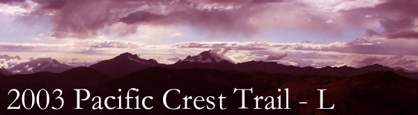
Day One
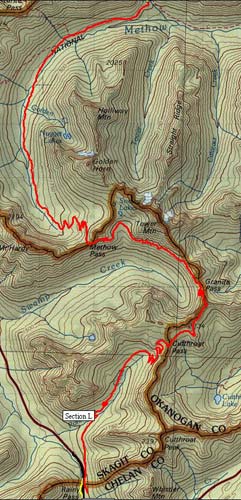
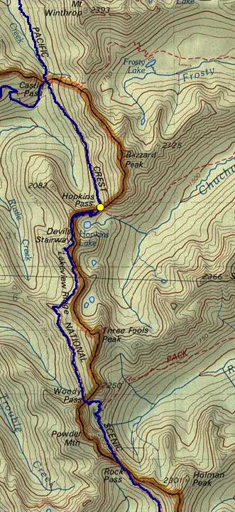
After Never being accused of too much common sense I was all eager to join the usual crew on the trail this August. In addition to Nick and Dan, Paul joined us at the Rainy Pass trailhead on the North Cascades Highway. After an attempt up Mt. Defiance tweaked Paul's knee he was in only for the first two days covering 33 miles. 33 miles in two days? How long is this hike? The northernmost segment of the PCT stretches 60 miles from Highway 20 to the Canadian Border at monument 73. Over the course of those 60 miles the trail climbs over 11,000 feet and drops a tad more than that. From the border to the Manning Park Resort it's another 12 miles and 1,000 feet of gain and a similar loss. We started at Rainy Pass at about 4,800 feet. The trail climbs gradually through the woods before emerging into the relatively barren Porcupine Creek valley leading to Cutthroat Pass. With just a few switchbacks and five miles we were at the crest at 6,800 feet. As we were climbing we were passed by a couple of trail runners. More were flitting around the pass and heading down to Cutthroat Lake. We also met a lady enjoying the view who said she was hiking to the Oregon border and had a month to do it. Lucky lady. From Cutthroat Pass we had a 2.5 mile traverse to 300 feet of switchbacks dropping to Granite Pass at 6,300 feet. Much of this trail, much of this segment, was above 6,000 feet, completely exposed, and bone dry. The large Fawn Peak Complex was burning 30 miles to the east and the rangers warned us of spot fires throughout the area. At Granite Pass we came across a youth group working working on the trail. They were camped two miles up the trail below the Snowy Lakes in a spectacular spot looking out over a 1,300 foot drop to Swamp Creek. We dropped our packs and climbed 300 feet to Lower Snowy Lake which was a bit disappointing, though it did sit just below the Golden Horn. We filled up with water and headed a mile up the trail to Methow Pass at 6,600 feet. Methow Pass stands above the West Fork of the Methow valley. The trail drops precipitously in a series of switchbacks to the valley floor 900 feet below, then continues to drop until Horse Heaven Camp at 4,300 feet. At the bottom of the switchbacks we paused to eat a bar (mmm, bar) and so Paul and I could work on our feet. I got out my bag of craisins and passed them around while I repaired my heel pad. As I was closing the bag I noticed a tiny stick mixed in with the dried fruit. "There's a stick in my craisins," I said. This quickly became "Get your stick out of my crazy!" and then "Get your hand out my crazy!" in a variety of odd voices. This would stick with us for the rest of the trip. It was around 6pm when we rolled into Horse Heaven and met Crazy Guy #1. Crazy Guy #1 had water bottles duct-taped to his hands and a tiny backpack on his back. He had left Manning Park at 4am and planned to run until he got to Stehekin. In case you need a little perspective, he had already run about 60 miles and was planning on another 15 to where we started, then another 30 miles. Still wondering why we called him crazy? Crazy Guy #1 thought Brush Creek, another three miles up the trail, was a lousy campsite, but did set us up for the next day. He went his way and we pushed on to Brush Creek which wasn't terribly attractive, but did have plenty of cold water and was big enough for our two tents. Dinner was a tasty "chili mac" which was sort of beef and noodles and chili powder.


Day Two
Crazy Last year day two was a disaster for me. I had spent most of my energy on day one in the woods along the Whitechuck River. When it came time to climb to Red Pass first thing in the morning I had nothing to give. Climbing out of Brush Creek was similar, but probably had more to do with hiking 20 miles the previous day. On the upside we were able to see helicopters dumping water on the Needle Creek fire. It was 40 acre fire burning just two miles down the Rattlesnake trail which intersected the PCT at Brush Creek. It's hard to imagine how much water they were dumping on each trip and how the fire could continue to burn with all that water, but still it smoked. Now that we were on top of the world, we traversed another 6.2 miles with minor elevation gains and drops, but nothing terribly special. We walked across a narrow ridge below Tatie Peak at 6,900 feet and began a long counter-clockwise rotation around Ninety-Nine Basin with Slate Creek running at the bottom almost 2,000 feet below us. In the final approach to Harts Pass at 6,200 feet we entered some more heavily-forested areas. We all came to a halt as something was seen moving in the brush to the left. A young deer sauntered across the trail into the clearing just downhill from us and continued eating as though we weren't there. Either it hadn't had any contact with people before and it was the trusting sort (in other words it'd be deer-jerky soon) or it had experienced too much of people and didn't find us threatening. Either way it merely watched us as we continued on to arrive at Harts Pass around 4pm. Since Harts Pass was (a) conveniently located 33 miles from Rainy Pass, (b) accessible by road, and (c) serviced by a shuttle Paul had chosen that as his exit. His ride was scheduled to pick him up at 6pm and drive him back to his truck at Rainy Pass. We took advantage of "the nicest Forest Service _______ I've ever seen" (according to Nick), talked with a ranger, and laughed at a biker who had been abandoned. Since we had another three miles to hike, mostly up hill, we bid Paul farewell and trudged up the road to a culvert the ranger assured us had water in it. Blast! It was dry. The next culvert, right next to the stock station, did have water so we filled everything we had including Paul's bladder which he had lent to us. Needless to say, we were heeding the warnings of just about every southbound hiker we had run into who said water was extremely scarce. The three of us took turns carrying the extra three liters the next three miles to our campsite at the source of Benson Creek, just short of Buffalo Pass. We set up camp in a hollow and stored our food in what may have been the best bear-proof tree ever. Our only problem was that we dropped a little bit of the beef stew, still in dehydrated form, on the ground near the tent. Big deal, right? A few hours later we heard snuffling and pawing and we peeked out the tent to see a deer (the same, doubtful) gobbling the freeze-dried goodness we had cast aside. There wasn't enough to test the wedding-rice-in-birds-bellies theory, but I'm sure the deer was thinking something along the lines of "how you get so big eating food of that kind?" Ah well.


Day Three
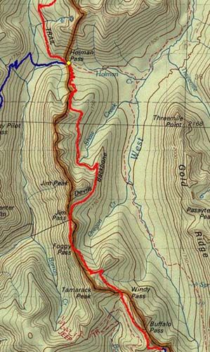
We We descended through Buffalo Pass and Windy Pass before coming up to a wall of switchbacks. Fun. From Windy Pass we climbed 500 feet to the top of the wall only to see we had to drop right back down to 6,100 feet at Foggy Pass. (Which, by the way, wasn't the least bit foggy. I suppose I should mention now that although there were plenty of times we thought it looked like it might rain in a few hours it never did. We always had at least partly sunny skies with mid-day temperatures in the 70s. Of course, it usually felt a lot hotter, but that was just the hills.) Foggy Pass was just a traverse away from Jim Pass which led us to the <queue the scary music> Devil's Backbone. We sat in the sun above the switchbacks which would drop us 500 feet and had chub and cheese and chocolate. I built a monument with random stones and took pictures. Soon enough we were descending along Satan's Spine (wouldn't that have been a better name?) and filling up with water at Shaw Creek at the bottom. The next mile and a half was a modest gain of 500 feet to the ridge overlooking Holman Pass. The drop into Holman was 1,000 feet in a mile and a half of long, wooded switchbacks. As we climbed down we again discussed the merits of climbing versus descending. True, descending seems to take less energy, but beats your joints mercilessly. Climbing requires more stamina and, for me at least, takes a lot longer. In the end, i think we agreed that they were both not as favorable as traversing, but climbing was better. Besides, my blisters were clustered on my toes and the balls of my feet rather than my heels so climbing was a lot less painful as well. Oh, did I forget to mention the return of the Blistermaker 2000 (TM) boots from Montrail? Yeah, the same boots as last year. I had them stretched. I put insoles in them. I wrapped my feet with preventative moleskin. In the end it helped but a little. By the third day I was pretty messed up and had begun the development of a blister on the big toe of my right foot that would later be known as Alfred. Dang. Regardless, we finally arrived at Holman Pass, elevation 5,000 feet, to find a large group of contract trail workers were camped there. We stayed only as long as needed to swat a few flies, consume some goo (the energy gel that didn't seem to work for me this year), and suit up for the climb out of the hole. Oh, yeah. You don't descend 1,000 feet and then traverse. You get to climb back out. In our case we expected to hike another mile and a half to the Goat Lakes trail and climb that to 6,100 feet. The next day we'd climb back down to the PCT and then right back out of the Holman lowlands. It seemed a monumental waste of energy, but we'd heard great things about the Goat Lakes so that was the plan. Unfortunately, when we got to the outlet stream for the Goat Lakes there was no trail. We did find a very primitive trail a little while later, but decided that clearly wasn't it. We continued on, climbing what was to be the first climb of the morning to emerge into a large meadow on the northern side of the lakes. We wandered about a bit looking for the lakes and did eventually find the lower of the two, but it was a bit disappointing. We filled our water and headed back into the meadow. Our campsite was about as dead-center as it could possibly have been. We had a couple of small trees and even a tiny stream running past. A much larger party was camped about a quarter mile downhill from us and a horse party was to the north. As the guides were taking their thousands of horses to the paddock near the lakes they told us we might see or hear the horses in the night, but they'd be hobbled and shouldn't cause us any problems. Uh huh. A more immediate problem was dehydration for me. I developed some serious chills and couldn't stop shaking even after I had all the clothes I had with me on. Heck, I even took a couple of shots of rum to try to get warm, but to no avail. We had turkey tetrazini with rice for dinner, but in the end I called it a day well before the sun went down and crawled into my sleeping bag. Sleep came easily after three days on the trail, but it certainly didn't last. The bloody horses and mules decided it'd be entertaining to gallop through the pasture all night long. We'd hear the dull thunder of their hooves as they chased each other from one end to the other. Of course, that wasn't all since they each had a bell on. Nick thinks the bells were tuned to A and C-sharp.


Day Four
In Needless to say, none of us are likely to stay with Early Winters (a resort in Mazama) or use their services any time in the future. Of course, it would be awfully nice to have steak and beer on the trail. Heck, they probably even carried a portapotty with them. Unfortunately, we were just a little late getting on the trail and wound up directly behind the six-horse, one-mule poop-machine as they started up the trail toward Rock Pass. At least we think it was Rock Pass. The problem was that Rock Pass didn't seem all that rocky. The next pass, though, had an insane number of rocks and in fact had a new trail below a rock slide that had all but erased the old trail. That pass, though, was called Woody Pass. Doesn't make much sense, huh? That's probably what had us buggered up the whole day. We felt we were making no progress at all because we thought we were a full pass behind where we thought we were. Regardless of which pass was which, we were saddened to see that we had to drop 700 feet on the pack trail to avoid the aforementioned rock slide. Dropping wasn't so bad, but then we had to climb back out plus an additional hundred feet to get to what we're now calling Woody Pass. We traversed another five miles along "Lakeview Ridge," though we saw precious few lakes. We climbed to another pass to see a beautiful lake below us (finally) which we took to be the first of the series of lakes we were supposed to see from this ridge. We climbed again and got to 7,100 feet. Dan took my picture at what turned out to be a turning point in the hike. We were as high as we would get and from here to the end of the trip there was no more climbing. It was all downhill. After mistaking Woody Pass for Rock Pass we had been hurrying all day to try to make up for lost time. In our haste we had wound up atop the Devil's Staircase staring down at Hopkins Lake. We discovered our errors while filtering water from the lake. Nick and Dan washed their hair and we had nourishing garlic mashed potatoes. These were clearly superior to the garlic mashed potatoes we had last year and it made me wish we had far more, but alas, it was the only bag. While we rested at Hopkin's Lake a young deer came down to the water and pretended we weren't there. Our goal for our fourth night was to make it a few miles past Castle Pass. While on the Staircase some southbounders told us there was a great campsite two kilometers (can you tell where they must have been from?) past the Pass. The trail was just after a meadow. We dropped 1,000 feet to 5,000 feet in the next five miles and did indeed find the wonderful campsite. Dinner was beef stroganoff with the last of the rice, the last of the rum, and all the vodka. Yeah, I know, when I say it like that it sounds like we were out to get drunk. We brought the alcohol to stave off the nasties in the event it rained on us the way it rained on Nick and Dan in 2001. Luckily it didn't, but that left us with two pints of very cheap booze to get rid of before we crossed the border. Many a twisted face later we were done and the plastic bottle went into the trash bag rather than the food bag. Eagles screamed at us as we prepared to sleep and another deer pranced through the campsite, but other than a sighting of Mars and its two moons it was a quiet night.


Day Five Our final day on the trail started with the need to use our gaiters. Like last year we all had tons of foul-weather gear we didn't really need. I was carrying extra gloves, ear muffs, rain pants, and my gaiters. Nick had prevailed upon me to leave my crampons in the car, thankfully, and my gaiters served well as we hiked out through the overgrown final section of the trail. Although most of the other parts of the trail were either in great shape or were being actively worked on we saw little sign there was any effort put into maintaining the last few miles before the border. There were stakes in the ground marking where work should take place, but unless someone gets out there soon it'll be too late in the season to do much good. On the upside, we did find a bunch of ripe blueberries that hadn't been brushed back from the trail. About two miles from the border we stopped in our tracks when we saw movement off the right side of the trail. Nick was hoping for a bear, but the packs on at the side of the trail indicated that was clearly not the case unless it was eating some poor hiker. No, it was a couple of smokejumpers working to get their parachutes out of the trees. They had jumped in the previous day to fight a tiny little fire way the heck up on a hill on the other side of the valley. They said it took them 35 minutes to go down to the bottom of the valley and up the 1,000 or so feet to where the rest of their crew was working. I think it would have taken us a lot longer, but I suppose that's what they pay those guys for. We gave them what info we could (distance to the border, to the road beyond the border) and continued on. Before we knew it we were at the border itself. An aluminum monument (number 78, to be specific) marked the line. A series of wooden pillars marked the northern end of the PCT. A 20-foot wide clearcut extending up the hills on either side marked the actual border between the US and Canada. Freaky. We took a bunch of pictures, including some with my patriotic Petsmart bandana, and headed into the Great White North which looks disappointingly just like the country we'd come from. No snow or nothing. The trail continued down to a junction with an old road and a paddock for horses. From here on we had no maps because the software I had used to generate our routes was for the US or Washington only, the PCT map we had was for northern Washington only, and the maps that were posted along the trail were too well affixed to be taken with us. Besides, those posted maps were inconsistent from one to the next. No matter, it was all downhill from here. No problem. Except that last 1,000 foot climb to Windy Joe Pass. Blast. And the illogical 20-feet up, 20-feet down bumps in the trail that nagged at us as we made our way north. Finally, it really was all downhill, but of the worst kind. We were on a logging road which twisted and turned and dropped rapidly. We could walk three abrest, but all six of our knees cried out. Once we were at the bottom of that we were on a dust-choked horse trail with loose gravel for several miles paralleling the river. This trail even went beyond where we wanted so we had to backtrack on the main road, but finally, mercifully, we arrived at the Resort. I checked in, covered in filth and stinking of five days on the trail. We were quickly ushered off to a cabin on the outskirts where we dropped our packs and sat down. I cut the tape off my feet (I'd gotten the foot-care portion of my mornings down to 20 minutes by day four) and jumped into the shower. Ahhhh. All clean, we headed back toward the restaurants where I had a splendid turkey-and-swiss sandwich with fries, Nick had a double-decker club, and Dan had a big, juicy baconburger. Amy arrived a little while later and she immediately pounced on my feet. Alfred, the three day old, unpopped blister on my big toe was enormous and probably qualified as a sixth toe. We took care of that and many of the others while Nick and Dan were at the bar. Amy left me on the floor with Clara so she could get some food and brought back an average burger for me.


Day Six Although we didn't hike on the final day of the trip, we did drive forever. It took a couple of hours to get from Manning to Starbucks in Abbottsford to the border at Sumas where the border guard was sure Dan had some BC Bud stashed somewhere on/in his being, but not so sure as to spawn a search. From there it was a simple drive south, with a stop at Taco Time east of Bellingham. We picked up Tokul at the Borucks', dropped Nick at his house in Seattle, then stopped at the doctor in Issaquah for a quick check of my feet. Doc had a bit of concern so I got a bunch of stuff for a doggy bag and a prescription for more. We took Dan out to dinner and then home, skipped puppy class (it was just a review anyway), and crashed into a house barely lived in for the last week. (Amy was in Portland from Saturday to Tuesday night.) All told it was 72 miles on the PCT plus a mile or two up and down to Snowy Lakes and Goat Lakes, neither of which were particularly worth it. Although we started counting switchbacks on the first two days, I lost track on day two. 46 for day one and around 38 for the second day. I kind of think it was a more difficult hike than the Whitechuck-to-Stevens hike of last year, but that might have been just because it is fresher in the memory. We're already starting to talk about next year. From Rainy Pass south to Glacier Peak and out the Whitechuck would be good because it would connect the past two year's hikes and make a continuous line from Canada to Steven's Pass. For Nick and Dan it would take them all the way south to Snoqualmie Pass. We're also talking about something in Oregon near Sisters, but we have tons of time to plan. |
||
 suffering complete blisterification on the Pacific Crest Trail
 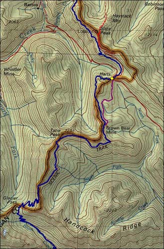 Guy #1 had said the climb out of Brush Creek was going to be a brutal one, but he was crazy, right? How much should attention should we really pay him? Turns out he was right. The trail starts up immediately and follows Brush Creek for 3.5 miles gaining 1,300 feet to Glacier Pass. In the next two miles the trail gains another 1,110 feet to 6,700 feet. Ugh.
 woke relatively early for day three to find it was frickin' cold outside the tent. Jimminy-Christmas-cold. In fact, the dew on the tent was all frozen and Paul's bladder, which was half full, was now half full of ice. Fog blanketed the valley below us, but we were in the clear. Yowza. We had a quick breakfast and jumped back on the trail to try to warm up.
 the morning one of the guides came by and asked if the horses had bothered us. We all showed great restraint and only Nick mentioned it was a little loud. What we really wanted to say was, "not only are you ___________ a bunch of disrespectful monkey _____ who let your ________ horses gallop through everybody's campsites, but you don't even do anything about your _________ horses' ______ all over the _______ trail."
![]()