Clara has had her eye on long distance hikes for at least a couple of years now. I don't know why. The longest I've ever done is 75 miles on the PCT, but that hasn't been since 2003. Wherever she got it, she has the thru-hiking fever with her eyes firmly fixed on the Wonderland Trail around Mount Rainier. That's a 93 mile loop with 22,000 feet of gain and loss. It's probably not a great route to start with.
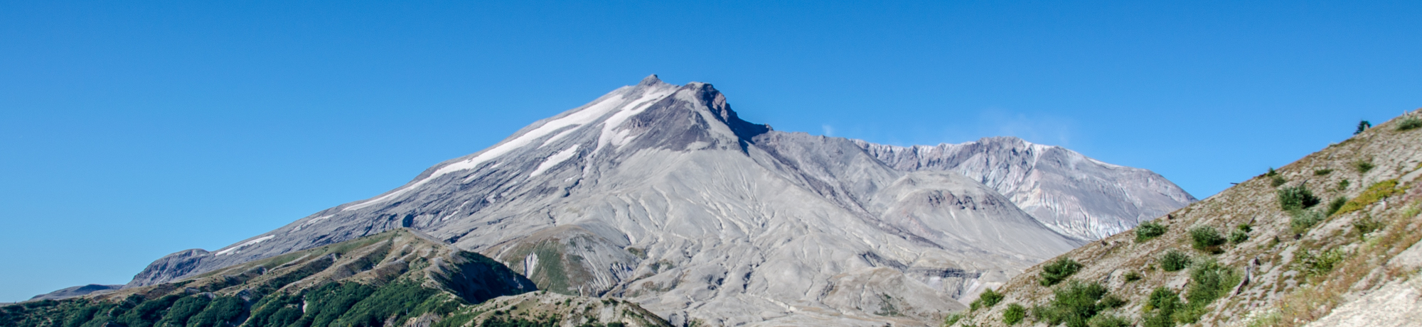
It turns out it's not just Rainier that has a trail encircling it. Many of the other volcanos in the Northwest can be similarly circumambulated. The shortest of these is Mount Saint Helens. The route is called the Loowit Trail, borrowing the original name of the mountain from the native language. It's only 28 miles with 6,000 feet of gain. That's totally doable in three days, but it would be a new experience for Clara.
On all of our other three day trips we had hiked in and set up camp, but then not moved camp on the second day. The big difference in this type of even modestly long distance is that you move camp every day. That means no easy second days and you have a destination you need to get to or the next day will be even longer.
We started to the northeast of the mountain at Windy Ridge. Just like with Henry we drove close to the trailhead and then slept in the car to get a fresh start in the morning. The first couple of miles were on a dirt road. The views of the mountain were great, but there's nothing joyous about a road walk.
We opted for a counterclockwise hike. That meant the majority of our first day would be in the Blast Zone. Yes, it sounds a little like the Neutral Zone or the Phantom Zone, but those are sci-fi and this is real. The Blast Zone is the 10 mile stretch of the Loowit Trail that crosses "The Breach."
Just in case none of this is ringing a bell remember that on May 18, 1980, Mount Saint Helens erupted. The north side of the mountain collapsed in the largest landslide ever recorded. Ash rose to 80,000 feet, glaciers melted and surged down the river valleys as lahars. 57 people were killed. 1,300 vertical feet of the mountain disappeared.
"The Breach" is the former north face of the mountain and we were privileged to hike right past it. In fact, we were required to hike right past it. There's no camping in the Blast Zone. Nor is there much of anything else other than some grass, scientific instruments, and gullies.
Oh, the gullies. The small ones were merely annoying. Drop 10-20 feet on loose rocks and sand, then climb back out. The big ones were 50 feet down and back up. The biggest was the last of the day where we dropped 1,000 feet to the South Fork of the Toutle River.
Along the way to camp we saw the 200 foot high Loowit Falls, found spectacularly clear springs and muddy creeks, and a few blueberry bushes with a few sweet, sweet berries still clinging under dried out leaves. The whole way it was really, really hot. When we found water we took advantage of the opportunity to get wet knowing we would dry out before we were out of sight.
Our last challenge of the day was descending the final 50 feet to the river with the aid of a hand line placed by the Forest Service. Over the next few days we'd see more of these ropes and whether we were going down a slope, up a slope, or crossing a fast moving stream they were always crucial to our success.
The sun set as we sat by the water with our macaroni and cheese. There was little talking or looking at the stars. We were just too tired. And because we were thru-hiking we would get to do it again the next day.
That next day came awfully early. Clara is just starting to embrace the joy of sleeping in, but not when the sun is hitting the tent. We were on the trail bright and early to try to beat the heat. The first two miles of the day were a consistently steep slog through old growth forest. Whenever I've had big climbs bright and early it's been hard for me. The same seems to be true for Clara. 1,200 feet of gain felt far higher and we slowed to a crawl. Until we found the blueberries. Then we came to a complete stop.
I've gorged on blueberries before, but it's never been like this. These berries were big and sweet and hanging by the trail in huge bunches. We ate so many it spoiled berries for much of the rest of the trip. At the time, though, it was the perfect pick-me-up to get us moving again.
We had been told it was pretty much dry almost all the way to our next camp, June Lake. Washington is known for being the place it rains all the time. Except here. We were rationing our water as we dropped into yet another gully. We'd been chatting, mostly about berries, but I heard something. Ssh... ssh! WATER!
About 200 feet down the gully a little spring welled up out of the ground. The brush was greener and the berries were plumper. We dropped our packs, filled our bottles, and had a well-deserved break. Although we still had miles to go before we could make camp we spent a fair amount of time with our packs on the ground instead of our backs. After a long first day and a hard climb we needed some down time.
We relaxed for almost an hour before we hit the trail again. We were refreshed by the time spent without a pack and the repeated hat-fulls of water dumped on our heads kept us cool. It was good we were in high spirits because the biggest mental challenge of the day was just ahead. Thanks to one of the forks of Coldspring Creek a 300 foot gully blocked the trail. Unlike the drop to the South Fork of the Toutle at the end of the previous day this was nearly vertical and completely unstable. Even a hand line wouldn't make it a reasonable descent. Instead, the trail detoured a half mile downhill to a spot where a crossing was possible... with a rope. We dropped down the slope and climbed back up the other side. Then we had to hike back up the other side for half a mile to get back to where we could have been if not for the gully.
Although it was the mountain that demoralized us by forcing the detour it rewarded us just a short while later with a tiny snow field. The snow was dirty, full of debris, and perhaps the best snow I've ever encountered. Once again, we dropped our packs. We thought of Treen rolled in the cold. I filled my bladder with snow and we packed it into our hats. (Don't worry, I had an inline filter to clean the melted snow before I drank it.) Sitting next to each other, we posed for a selfie. Each of us thought we were being so sneaky with a handful of snow slowly raised to the other's neck. It turns out great minds think alike (and so do ours).
From our party in the snow we entered the first lava flows on the south side of the mountain. Although the Breach occurred on the north side there were much older eruptions that sent lava down the south side. These also happen to be where the standard climbing routes are so we saw a few more people crossing the Loowit. For us, it meant stumbling through the sharp rocks and searching out the trail when it disappeared beneath our feet. When we lost it completely we'd look for white fence posts that served as markers.
We knew we were close to the end of the day when we crossed Swift Creek at Chocolate Falls. The waterfall was pretty and all, but we had nothing in mind beyond getting to June Lake and setting up camp. After the brutality of the lava flows the lush greenery descending to June Lake was amazing. June Lake itself underwhelmed as more a bog with a waterfall than a real lake, but there was plenty of space to set up camp and hang our food as the darkness closed in.
Morning. Retrieve the bag of food from the tree. Coffee and cocoa by the lake. Hey, what's that yellow thing in the bushes? Um... underwear? Seriously? Warning: It's rant time.
I. DO. NOT. UNDERSTAND. WHY. PEOPLE. LEAVE. THEIR. TRASH. IN. THE. MOUNTAINS.
Come on. It's not hard to pick up your trash. You bend over and pick it up. AIGH! Who leaves garbage in the mountains? It seems like there are a couple of different kinds of people that leave trash.
There are the accidental litterbugs. I'd put myself in this category. Over the course of 30 miles I'm sure I dropped a little scrap of something here or there completely unintentionally. Bugs like me pick up trash when we find it so it evens out.
There are the people who leave little bits because they don't think it matters. By far, the greatest number of individual pieces of litter we saw were the tear-off tops of packets of gu. Each piece is perhaps two square centimeters so it's not a lot, but they were everywhere and it was frustrating especially since those packets aren't exactly biodegradable.
Then there's the people who leave their underwear in the bushes. I can't even...
Ahem. Sorry. Rant over.
Our last day started with a mercifully short climb back up to the Loowit. On the way down it felt like we had dropped a ton of elevation in the trees. Thankfully, only a part of that was on the spur trail to June Lake. The downside was that the next 4.5 miles were a non-stop climb. In the trees it wasn't that bad, but soon we were back out on the lava flows and although it was early it was hot. After two miles we were close to meltdown.
I've been learning that everyone melts in their own particular way. It shouldn't have taken me 14 years with Clara to realize that she gets angry. We were only two miles into the day, but the grade was about 20% and we could look ahead at more and more climbing. When Henry melted down on the first day of his trip in the Buckhorn Wilderness I had let him stew while we continued with no other real option.
With Clara we also had no option but to continue. I tried to make that case, but it didn't help. She retreated into herself as we hiked slowly up the hill. As much as I wanted to encourage her I came to realize she needed time to herself. I was never more than a quarter mile ahead, but that was enough for her. When we topped out we had a brief rest in the shade, but pushed on. It wasn't until we crossed a feeder to Pine Creek and found some trees that we dropped our packs and napped.
Yes, there was some actual loss of consciousness. Clara slept for about 15 minutes while I rearranged some of our gear and ate a bar. When she woke she was a new person. It completely reset her attitude just as the blueberries and cold creeks had on days past.
We certainly weren't done with the hike, though. There were two more big gullies to cross where we found the water was as muddy as you'd expect from Muddy River, but amazingly refreshing when it filled a hat.
The final stretch of the hike was across the Plains of Abraham. I'm not particularly well versed in biblical history so I wasn't sure if it was to be more milk and honey or 40 years in the desert. Thankfully, it was more the former than the latter. The terrain was mostly flat with a creek running through it. We made great time on the Plains and found ourselves at the junction with the Abraham Trail.
On the map, this trail looked like a shortcut back to the Truman Trail and to the car. In reality, it was a no-fun traverse along the east side of the ridge. No views of the mountain, the berries were no good, and we were so tired we had little interest in walking further. The only thing that kept us going was the memory of a spring on the side of the road just ahead. We found it and the water was lovely, but pretty much any liquid at any temperature would have been welcomed at that point.
After 30 miles around the mountain Clara had completed her first thru-hike. Like the trail dropping into gullies and climbing back out, the experience was a roller coaster of emotions. We started with nervous excitement that morphed into just another hike. As the miles stretched on we had no choice but to continue. Moments of thrill punctuated the otherwise routine of our new day-to-day life. (It's funny how quickly we adapted to a life of hiking with little regard for what was happening off the trail.)
As tired and sore as we were it's clear long-distance hikes like this are going to be a continuing feature in our lives. We're not ready for the 93 mile Wonderland Trail, but the Timberline Trail around Mount Hood is 40 miles, which might be about right for next year's big adventure. If she keeps up her enthusiasm she might work up to the Wonderland before she heads off to college. Of course, if she does the Wonderland she might really have the long distance hiking bug and that can only lead to the Pacific Crest Trail. I hope she invites me to go along.